


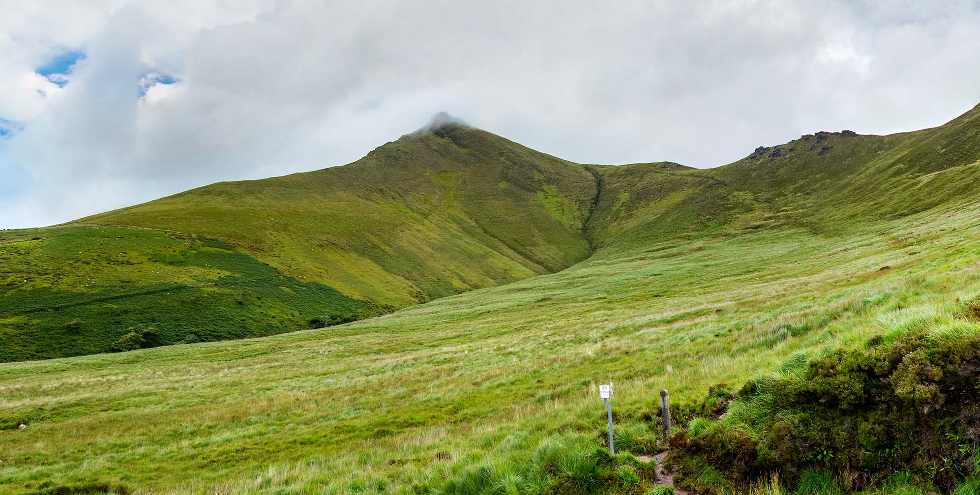
24 Aug Caherconree Promontory Fort
“From the situation of the place it resembles a beacon, or place of guard to alarm the country; but, from the prodigious size of the stones, it rather seems to be a monument of some great action performed near this place, or perhaps a sepulchral trophy raised over some eminent person.…The country people, from the height and steepness of it, and the largeness of the stones, will have it to be the work and labour of a giant, and it seems indeed wonderful how human strength, unassisted by engines, could possible raise stones of such a prodigious weight to the summit of so steep and high a mountain.”
Ancient and Present State of the County of Kerry, 1756 1
Click the image above to enter the virtual-reality tour.
The tour begins at the trailhead, with the fort’s cloud-shrouded promontory high above.
“Why did the men of Ulster slay Cú Roí mac Dáire? Easy to say. Because of Bláthnat who was carried off from the siege of the Fir Fálgae…”
The Tragic Death of Cú Roí mac Dáire, 15th century 2
Cú Roí mac Dáire was a legendary sorcerer, a great magician who was said to reside in the south of Ireland in the brutal tribal era of prehistory. He has given his name both to the mountain and to the stone fort near its peak.
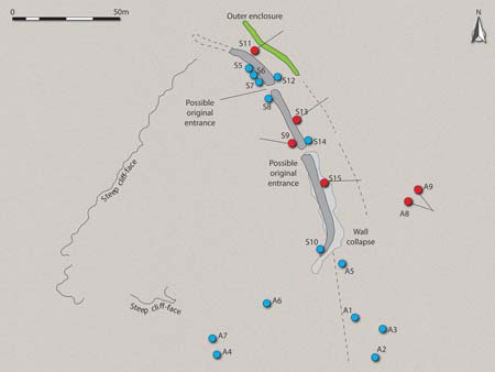
All that remains of his stronghold, Caherconree (“The Fort of Cú Roí”) is a tumbling stone wall, 110m (361 ft.) long, 4m (14 ft.) thick, and 3m (10ft) at its highest point. It cuts off a narrow triangle of land 615m (2,018 ft.) above sea level. The interior of the fort is protected by forbidding cliff edges to the north, west, and south. Internal terracing, of two steps, is apparent throughout much of the wall. Two possible original entrances have been identified at the north-east. Absent any datable finds, archaeologists have given Caherconree a tentative Late Bronze Age date (c. 1500–500 BCE).3
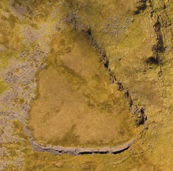
Click for a higher altitude view of the fort.
Archaeologists classify this type of monument as a “promontory fort,” and this is the second highest one in Ireland.4 With the walls guarding its entrance, and forbidding sheer cliffs protecting its other two sides, this small triangular refuge of about 1.22 hectares (3 acres) on a remote mountain may have been a sanctuary to use when all else failed. If so, it was a sanctuary with an incredible view: westward the length of the Dingle Peninsula and southward down to the Macgillycuddy Reeks.
In the initial view of the virtual-reality environment, made at the small car park at the trailhead, you may click on the red hotspot to proceed directly up to the promontory. After exploring the fort you may take a more scenic virtual hike down the mountain using other hotspots. The VR tour was compiled from photographs made in visits to the site from 1999 to 2024. The fort’s location may be seen in a satellite view.
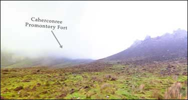
The Caherconree promontory rises some 370m (1214 ft.) above the small carpark and trailhead on the narrow road that threads through the eastern end of the Dingle Peninsula. In bardic tradition the magician-warrior who occupied the fort had the power to confound his enemies by causing the fort to rotate or vanish.
In reality, from the carpark the entire promontory can seem to disappear and reappear in an instant due to the clouds that often gather at the peak. In fact, in our VR tour (above) the initial view shows the promontory enmeshed in the mists of the mountain.
Early antiquarians were similarly confounded by the fort’s furtive physicality, such as during John Windele ascent in 1860:
Unfortunately, although the day was otherwise fine, the summits were concealed from view by a sluggish covering of vapour, which afforded but little hope of speedily clearing away….The ascent was indeed full of labour, the more so by reason of the great obscurity through which it was made, the cloud in which they moved not permitting the party to see a yard before them in any direction.” 5
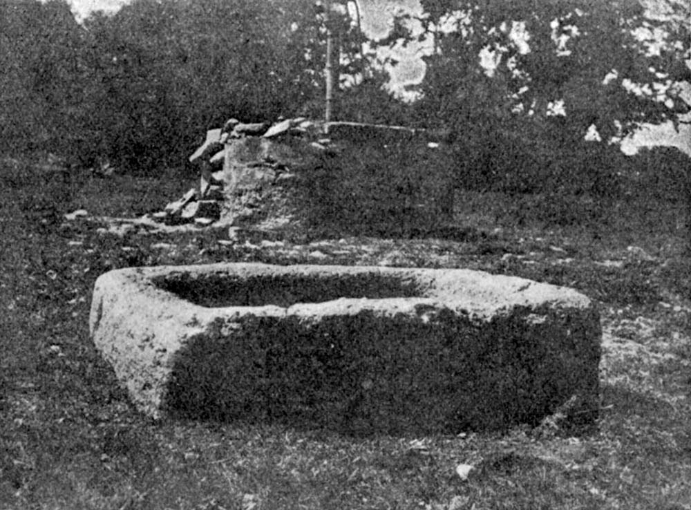
A stone trough from Caherconree.
Due to its remote location and difficulty of access Caherconree has not received the degree of attention from archaeologists that its prominence in the traditional literature would seem to warrant. In fact, during the 71-year period between the fable-focused account of Timothy Scanlon (1948) and the drone-based photogrammetry research of James O’Driscoll (2019) there does not appear to have been any published research focusing upon the monument. This is understandable, as any extended ground-based archaeological research would likely require the establishment of a self-contained base camp on the site, perhaps with a camping trailer helicoptered onto the promontory.
We will focus upon O’Driscoll’s research below.
Another reason for the dearth of academic attention to the monument may have been that no less a luminary than John O’Donovan insisted in 1841 that no traces of the fort remained on the promontory at all. The tone of finality (“… utterly erroneous…”) in his assessment may have served to discourage any hikes up the mountain by later investigators.
“…Dr. Smith, in his History of Kerry [1756], states, that the ruins of it [Caherconree] were to be seen on the summit of the mountain in his own time. But this is utterly erroneous, for the feature called Caher Conri on this mountain is a natural ledge of rocks.” 6
However, according to Westropp (1910) O’Donovan neither climbed the mountain nor spoke with anyone who did so.7
Caherconree in Irish Legend.
In the Triads of Ireland (c. ninth – 14th century CE), it is named as one of the three oldest buildings in the land. In the 12th-century tale of The Battle of Magh Rath, said to have been fought in 637 CE, the text mentions the fort:
“Seven battles around Cathair Conrui,
The plundering of Fiamuin, son of Forui,
The plundering of Curoi—lasting the renown,
With the seventeen sons of Deaghaidb.” 8
The Tragic Death of Cú Roí mac Dáire is one of a group of sagas which feature this half-demonic person with magic powers. There are numerous versions of it in early Irish and it is echoed in stories in Wales and even in Belgium.9 The oldest version is found in the Yellow Book of Lecan, now at Trinity College, Dublin. It was written around the start of the 15th century and may be based upon stories transcribed as early as the 11th century CE.10
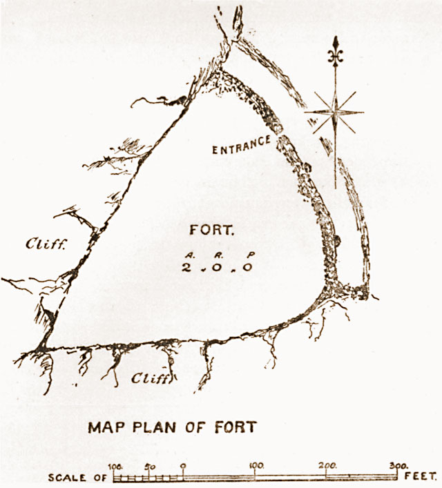
Fort Plan, P.J. Lynch, 1897
At first Cú Roí was allied with the great hero Cúchulainn, the “Hound of Ulster.” But after a ferocious battle in Scotland, when they were dividing the plunder, they did not give the magician Cú Roí his fair share. Although Cú Roi was, by right, able to claim as his reward the lovely lady Bláthnat, Cúchulainn wanted the woman for himself. When Cúchulainn would not agree to turn his lover over to Cú Roí, the magician turned upon him, thrust him into the earth to his armpits, cropped his hair with his sword, rubbed cow-dung into his head, and then went home to his fort on top of the mountain. He took Bláthnat with him as his wife.
His fortress was impregnable. Not only was it situated on this forbidding, isolated mountaintop, but it was also guarded by Cú Roí’s magical powers. At night, when he slept, he was able to make the fort spin around and around, confounding his enemies.
“In what airt soever of the globe Curoi should happen to be, every night o’er the fort he chaunted a spell, till the fort revolved as swiftly as a mill-stone. The entrance was never to be found after sunset.” (Yellow Book of Lecan: The Feast of Bricriu) 11
But Bláthnat’s love for Cúchulainn was greater than the evil Cú Roís magic. After Cúchulainn’s hair grew back and he regained his courage, they plotted the demise of Cú Roí.
Click to enter an annotated VR view of the Slieve Misch Range.
Bláthnat flattered her husband by telling him that the construction of the fort was not suitable for one as great as he. So the magician sent his warriors out to gather more stones so that the fort could be enlarged. While the fort was undefended, Bláthnat hid Cú Roí’s weapons. As he slept, she poured milk into the stream that runs down the mountain. Cúchulainn and his men, camping in the valley below, saw the stream turn white, and knew that the time to attack had arrived.
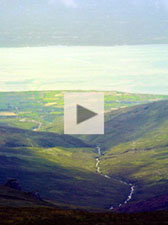
The White Brook
They rushed up the mountain with a roar and slaughtered the magician and his entourage. Bláthnat and Cúchulainn were reunited. The mountain stream that she used as a signal is today called Fion Glasse (“White Brook”). With just a little imagination, when the afternoon light glints off the rushing water, it again becomes a milky message (see video to the right).
However Cúchulainn and Bláthnat did not live happily ever after. A few years afterwards, Cú Roí’s poet Ferchertne, who survived the attack, encountered Bláthnat along a mountain path. He grabbed her and then jumped off the cliff, providing Cú Roí with vengeance from the grave for the betrayal. They were buried at the foot of the cliff, at a place still known as Feart Bláthnat agus Feirceitne (“The Mound of Blaithne and Feirceitne”).12 Much later, Cúchulainn, mortally wounded by Cú Roí’s son Lugaid, would expire bound to a standing stone in Co. Louth, Clochafarmore (“the Great Man’s Stone”).
“Sad was the struggle together
Of Bláthnat and Ferchertne,
And the graves of them both are
In the powerful land of Cenn Bera…Bláthnat was slain
In the slaughter above Argat-glen,
A grievous deed for a woman to betray her husband.” 13
In another version of the story Cú Roí’s soul went into an apple, which was eaten by a salmon who lived in the stream and only came to the surface once every seven years. In this story Bláthnat found out about the fish, told Cúchulainn, who then killed the fish.14
The Tragic Death of Cú Roí mac Dáire may be read in its entirety here. Cúchulainn is also a central character in the Táin Bó Cúailnge (“The Cattle Raid of Cooley”).
“There is a heap of loose stones, that appear to have been collected on a mountain in the county of Kerry, called to this hour, Curaidh’s Fort. The story is true; the detail is fabulously embellished; for this highly mental people loathed and disdained a barren and jejune narration.”
Theophilus O’Flanagan, 1808.15
These two high-resolution photographs were made with a large-format view camera in 1979. Click the photo, and then click the button at the right of its Zoomify toolbar to see it full-screen.
The fort of Cú Roí is on the promontory, upper left.
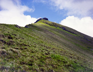
The mid-point of the climb.
Is it possible that the warrior culture depicted in The Tragic Death of Cú Roí mac Dáire might represent more history than myth? Scholars believe that the language and other clues contained in some of the Irish sagas indicate that none could have been written down before the eighth century CE, but that there might have been a long period of oral transmission before that time. And while most cultures go through a Heroic Age, dominated by aristocratic warrior cults, it is likely that none of the individuals in the story are historical.16
At one time there may have been far more extensive remains of the fort of Cú Roí. In an 1899 report the antiquarian P.J. Lynch wrote:
“I have been informed that some years ago the farmers living on the south side of the mountain were in the habit of removing the long stones from the Caher, and using them as lintels in the building of their houses. The means employed was to secure a chain around the stone, and yoke it to a donkey or mountain pony; this would account for the disappearance of the covering stones, and to the destruction of the entrance…” 17
A decade later Lynch discovered a “relic of Caherconree,” a basin stone that had been removed from the fort around 1830 and brought down the mountain to a home near Killorglin. Lynch’s photograph of this stone, which was known locally as “Finn Mac Cumhaill’s Saucer,” may be seen above.18


Modern Archaeological Research
“[Hillforts] may have been deliberately positioned in the landscape to attract traders and assert the authority of an elite over the movement of goods and people….The elites who controlled these forts and the communities associated with them may have resided there permanently with a retinue of warriors, craftworkers and other significant individuals, while the disparate community spread throughout the immediate landscape would gather at the fort at certain periods throughout the year.”
James O’Driscoll (2023) 19
In 2019 archaeologist James O’Driscoll used a drone to capture 183 aerial photographs of Caherconree. These high resolution overhead and oblique-angle images were used to create 3D models using photogrammetry. From approximately 8,430,430 three-dimensional data points Dr. O’Driscoll used the models with GIS software to extract new revelations about Caherconree. This was to be the first published archaeological investigation focusing upon the site in 71 years.20
Unlike the earlier antiquarian investigations of the fort considered above, which largely focused upon the high drama of Cú Roí, Cúchulainn, and Bláthnat, O’Driscoll used only a single sentence to provide the mythological context to his research at Caherconree. Instead, using modern non-invasive archaeological tools he revealed hidden features that provide a tantalizing suggestion of what may remain hidden under the deep layer of peat covering the interior of the fort.21
Previous laser-scanning surveys of such monuments by The Discovery Programme, with technology both time consuming and expensive, were limited to the monuments themselves and unable to retrieve important contextual data from the adjacent landscape. Without such datapoints, GIS spatial analysis tools such as slope model (similar to a topo map, but with more detail and accuracy), viewshed analysis and least cost path cannot be identified. O’Driscoll’s research filled in these blanks.
Click for an interactive look at some of James O’Driscoll’s research findings.
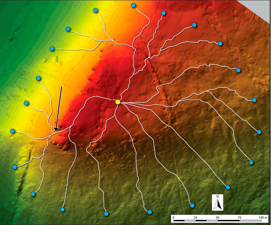
Visitors to the fort today will likely note the D-shaped structures built into, or just adjacent to, the wall (noted here in the VR tour). Without excavation, it is unclear which of these may be the foundations of hutsites contemporary with the fort and which (if any) date from the historic era, perhaps built by shepherds for temporary shelters, using stones taken from the fort’s wall. While seven of these structures had previously been identified, six additional house sites were recorded inside the fort by O’Driscoll’s photogrammetry survey, with another five abutting the external face of the wall. A further eight structures were identified immediately outside the fort to the south and east, as shown in the interactive diagram to the left. O’Driscoll noted, “An impressive complex of possible hut structures has been identified at Caherconree…highlighting the curious occupation of an inaccessible, high-altitude fort.” 22
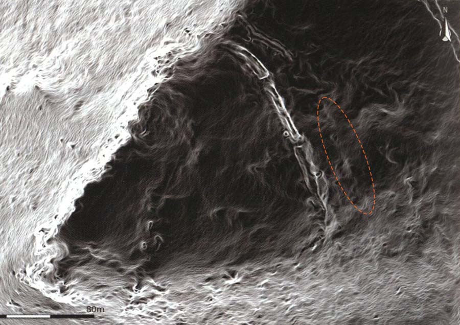
While some of these hut structures may be distinguished in the raw aerial photographs, it was the GIS interpretation of the slope model that identified circular terraces cut into the natural slope that suggested the locations of other likely foundations. The slope data also identified evenly spaced depressions in the northern section of the inner wall, which may indicate where work gangs completed different sections of the structure.23 Perhaps most signficantly, the slope model confirmed the existence of a second defensive line, a bank and ditch, which would have extended from the 25m (82 ft.) section visible today (noted here in the VR tour) to parallel the stone wall across the entire width of the promontory. The evidence of the extended bank and ditch may be seen here in the slope model.
“Considering the antiquarian evidence corresponds with the information gained from the current survey, we can now consider Caherconree as a multivallate [more than one defensive rampart] hillfort, with two widely spaced enclosing elements. Although this is a significant finding, it fits well with other high altitude inland promontory forts in Ireland, as prior to this survey, Caherconree was considered the only example of its type to be univallate. Now, we could suggest that multivallation is a defining characteristic of this site type.” 24
Another way of looking at the slope data is to subject it to “least cost path” (LCP) analysis, which identifies the optimum path of travel between any two points on the targeted landscape. With this analysis O’Driscoll identified “two curious breaks” in the precipitous edge of the cliff at the end of the promontory. One of these, about 4.2m (14 ft.) wide, with an overhanging rock face on both sides, would have created a “sense of spectacle if used as a formal entrance.”25 This potential ceremonial entrance may be seen in the LCP analysis (see arrow) here, and in the VR tour here.
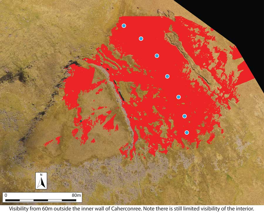
By using slope data to extract “viewshed analysis” O’Driscoll determined that the fort’s defensive wall was able to largely obscure its interior from the critical 60m point:
“…60m is the approximate distance for effective use of sling stones or other projectile weapons used during the Late Bronze Age or Iron Age. We could consider the height of the wall, which in places is over 3m, to have been built to deter attackers as well as obscure visibility of the interior within a buffer zone of approximately 60m. On the lower slopes surrounding Caherconree, visibility of the interior is almost completely blocked by the natural terrain.” 26
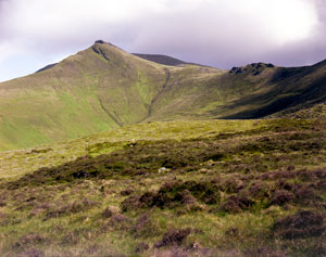
A hike up the mountain.
“On two of its sides it is defended by the natural rock, inaccessibly steep, a character which, in the wild heroic ages of insecurity and aggression, particularly recommended it as a meet site for an Acropolis, since it required but little aid from art to render it most impregnable.…Its ruggedness, immense elevation above all the neighbouring region, and savage features of strength, gave it an importance beyond every other consideration, and made it a meet abode for a king who ruled over men accustomed to aggression…” John Windele, 1860.27
The start of the steep trail up to the redoubt of Cú Roí begins at its small parking area on the barely paved mountain road called Bóthar na gCloch (“Road of the Stones”) that bisects the Dingle Peninsula east of Anascaul. The climb up the mountain presents certain difficulties. Out of the seven fieldwork visits to the Dingle Peninsula to climb to the fort we reached the promontory but three times in 46 years.28 On only one occasion was the weather on top completely clear. The first mile on the path traverses wet bogland, with spongy vegetation covering sinkholes into which you can plunge up to your knees in cold peaty muck. Beyond that is a half mile of climbing through areas of loose rock. There is always the threat of the clouds, which can descend suddenly, leaving no visibility at all. The striped posts placed at intervals on the mountainside are only marginally helpful for locating the trail when this happens.
Click to enter a VR view of an attempt to climb the mountain in the fog.
In the very wet summer of our visit in 2024, hikers had so abraded the peat cover that parts of the trail were composed of extremely slippery mud. To avoid the mud, hikers created new paths, which soon were also composed of muddy parts. Furthermore, the red-tipped white posts intended to guide walkers to the path when the clouds descend were in poor condition, with several fallen and others in desperate need of repainting. Perhaps a Kerry climbing club, or a local government body, will find the will and the funding to lay down a proper gravel trail up the mountain to protect the fragile upland bog terrain and to make the path safer for those visiting the fort. Until that time, we would strongly recommend that you download a GPS-based hiking map of the trail, such as this one on AllTrails, that can safely guide you down the mountain when the path vanishes in the fog. Be sure to download the route when you have a strong signal, prior to the start of the hike.
In the late 1850s a group from the South Munster Antiquarian Society climbed up to the top of Caherconree to explore the ruins of Cú Roí mac Dáire. One of them wrote a poem after seeing his companions enveloped in the mountain’s mist:
“We went our way, for ’twere dishonour
If e’er it should be said that we
Scared by the legends of the valley
Saw not the towers of old Conri.No sooner went we up the mountain
That all at once we lost our way;
The mists in clouds came curling round us,
And led-our eyes and steps astray.” 29
Click here to see all the notes from this page.
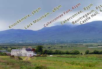
Caherconree, Co. Kerry
Nearest Town: Tralee
Townland: Ballyarkane Oughter
Latitude: 52° 12′ 10.9″ N
Longitude: 9° 51′ 13.36″ W