09 Nov Carrowkeel Passage Tombs
“The road winds gently upwards on ever narrowing roads, until the last of the cottages is left below. The hills are shiny green-brown velvet moss-covered peat, torn by grey-white limestone of often startling shape…Ahead, you turn into a gated valley, and it feels as though you have left the world behind, entering into a secret and silent place. You can see the road winding up, snaking higher in hairpin bends…The cliffs, green and limestone grey, rise on each side of you now and are peaked in many places by sudden domes, like bald-headed giants rising above the hill tops.”
Chris Thompson, Story Archaeology, 20121
Click the image above to enter the virtual-reality tour.
There is a line of passage tombs stretching west to east across the middle of Ireland, from Knocknarea and Carrowmore near the Sligo coast to the fabled Brú na Bóinne tombs near the east coast of Co. Meath. The 15 passage tombs of the Carrowkeel Complex lie on this line created by the eastward spread of Neolithic burial practices some 6,000 years ago.
The Carrowkeel tombs were excavated in 1911—some left in ruins—by R.A.S. Macalister. There were to be no further major excavations at the site, nor any detailed reassessment of Macalister’s dig for a century, until the publication in 2013 of “A century of archaeology—historical excavation and modern research at the Carrowkeel passage tombs, County Sligo,” (PRIA) by Robert Hensey, Pádraig Meehan, Marion Dowd, and Sam Moore. Some of the information below has been drawn from their work and we are grateful to be able to share some of this important new research with another audience.
While The Carrowkeel Passage Tomb Complex is dramatically situated and encompasses a wide area, neither the 1911 fieldwork of Macalister nor the recent article by Hensey et al suggested that the site shared the rich folkloric traditions and mythological associations of the passage tombs on the west or east coasts of the country.
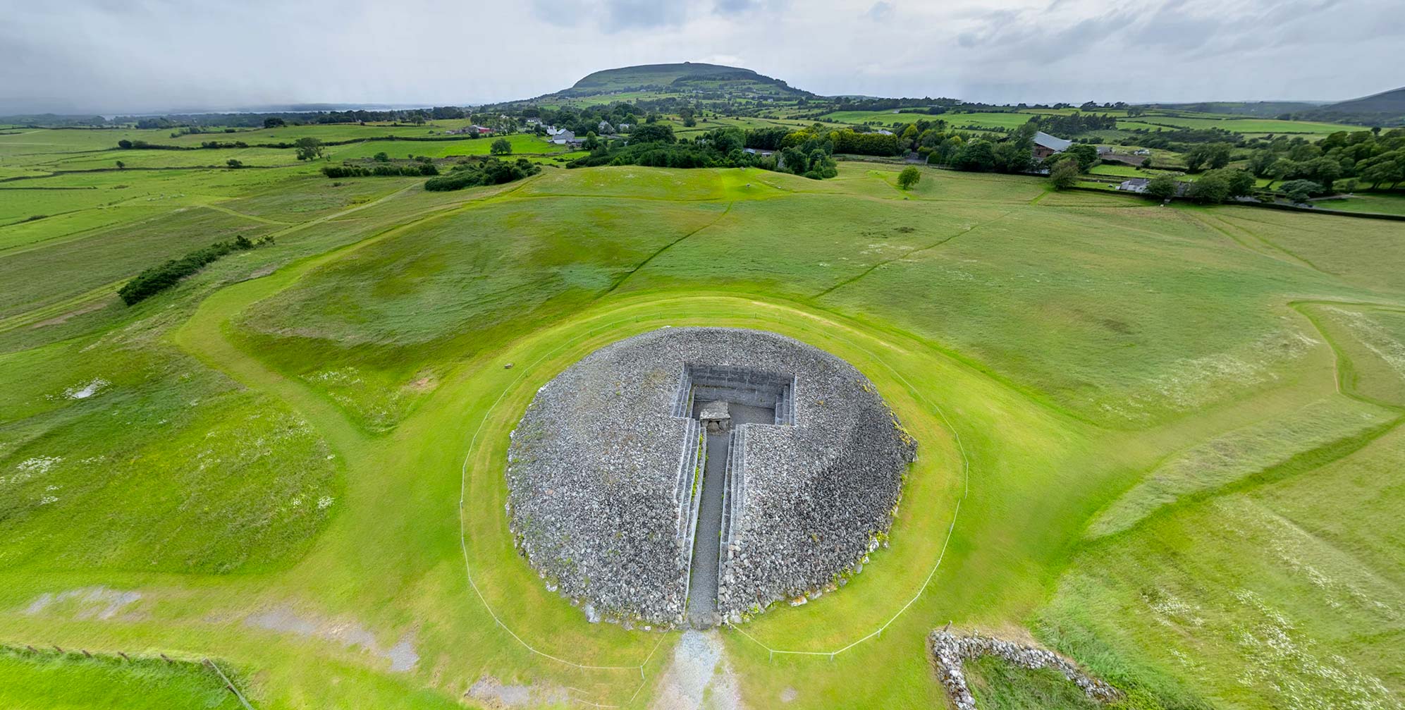
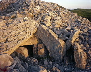
View of Cairns G and H from above.
Click to view in high resolution.
Located high above Ireland’s west coast, Knocknarea has its place in legend as the burial site of Queen Maeve. And Newgrange, the jewel of the eastern necropolis on the Boyne, is associated with the good god, the Dagda, and his son Aengus Óg. The later Bronze Age populations, and the still later Celtic-speaking peoples who arrived in Iron Age Ireland thousands of years after the great passage tombs fell into disuse, still held them in veneration, believing them to be the homes of gods.2 Yet Carrowkeel, abandoned and its tombs partly enveloped in blanket bog, was forgotten, its chambers violated by neither invading Norseman nor modern treasure seekers.
The hilltops received only a cursory examination by the Ordnance Surveys of 1836 and 1885, with no recordings of local tradition and scant information about the passage tombs, some of which were used as trigonometric stations but not otherwise noted. The tombs were largely intact when rediscovered and hurriedly excavated in 1911. Located in a depopulated area and lacking any traditional names, the cairns were designated by letters, the nomenclature still used at Carrowkeel today. Entirely unknown until 1911 were the hut foundations of an extensive village on a remote promentory beneath the Carrowkeel tombs, with evidence of habitation from the Neolithic to the Bronze Age.
While some of the local farmers of an older generation may still recount stories of how they saw lights and heard music coming from nearby “fairy forts” (earthen ring forts), they have no tales to tell about Carrowkeel.3 Only one of its stone tombs, Cairn C, had a local name suggestive of a folkloric tradtition: the Leprechaun’s House. However tantalizing the name there was no story that survived to explain its origin. Yet just to the west of Carrowkeel, the Caves of Kesh have a rich mythic tradition, as does the Heapstown Cairn to Carrowkeel’s northeast.4
Nonetheless, there is a hint of magic in the name of the strangely shaped finger-like projections of the mountain range: Carrowkeel (An Cheathrú Chaol: “the Narrow Quarter”) is located in the Bricklieve Mountains, 322 m (1057 ft), in a breathtakingly scenic location just to the south, and looking down on, the length of Lough Arrow. Bricklieve derives from Breac Sliabh, “the Speckled Hills.” In old Irish the word “speckled” describes more than an irregular surface pattern; it can suggest a portal into the realm of magic.
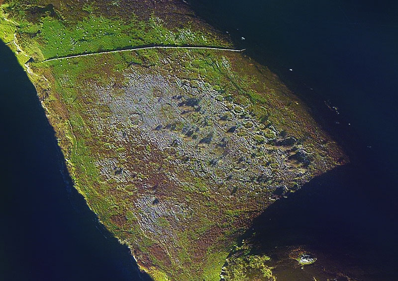
The foundations of some of the 153 hut sites, perhaps once occupied by the builders of the Carrowkeel tombs, are visible in this enhanced satellite image of the Mullaghfarna plateau.
The road up to the Carrowkeel hills may only take the visitor 20 minutes away from the rushing traffic of the N4 at Castlebaldwin. But it is a world apart, with a transition from a modern community to a landscape of deserted blanket bog and heather-covered hills, punctuated with jutting limestone cliffs and rift valleys. The pavement ends, and as the road enters the Bricklieve Gap the visitor must stop to open a metal gate, closing it afterwards to arrive at a privileged place of discovery, with no admission kiosk, government tour guides, or gift shop to interfere with the authenticity of the experience. Even more intriguing, several of the passage tombs may be entered by carefully crawling (kneepads suggested) into the womb-like burial chambers. After a few moments your eyes will adjust to the dim light coming in through the passage and you will be reborn into this liminal realm.
In our virtual-reality environment above, you can explore four of the cairns and an overlook of the hut sites on the Mullaghfarna plateau within 11 different VR nodes. During this tour you can enter into two of the passage tombs, Cairns G and K; no kneepads required.
Regardless of its empty record of traditional lore, Carrowkeel has been a captivating destination for the modern antiquarian visitor, and especially those drawn to “places of power.”5 Researcher, musician, artist, and tour guide Martin Byrne (The Sacred Island) was so taken with the landscape and its monuments that he pulled up roots and moved to a cabin in these hills. At Carrowkeel the remote past is a haunting and palpable presence. Byrne spent a decade in residence there, living as a neighbor to the Neolithic.
“This whole area, a good chunk of County Sligo was one of the most important centres of neolithic Ireland. Carrowmore and Carrowkeel are joined by the Uinshin river which flows from Lough Arrow to Ballisodare Bay, the main road through the thickly wooded region. It is a landscape rich with physical remains of the ancient past, and mythical echoes that can still be perceived in the majesty of the locations and views from the top of the mountains across the plains of Sligo.” 6
The passage tombs of Carrowkeel were constructed in the Neolithic (c. 3200 BCE) and continued to be used for burial rites into the Bronze Age (c. 2000 BCE). Once the last funerary items were inserted in antiquity, the chambers were sealed and did not again see sunlight until R.A.S. Macalister’s excavation of eight tombs, completed in just 15 working days during three visits in 1911. This exercise in speedy fieldwork one author has labeled “a blot on the reputation of Irish archaeology.”7 With scant attention paid to the tombs’ floorings, where no person had tread in perhaps 4,000 years, Macalister and his two comrades recklessly destroyed a capstone that impeded the progress of their excavations, which were more an establishment-sanctioned tomb raid than a scientific examination.8 If conducted under modern standards, it is likely that a full season of work might have been devoted to a single cairn. But Macalister and his colleagues Armstrong and Praeger, believing the tombs to be of Bronze Age construction, seemed most interested in the possibility of finding valuable artifacts, perhaps even a fabulous Bronze Age golden hoard. In his memoir, R.L.I. Praeger describes his first entry into an intact cairn:
“I had the privilege of being the first to crawl down the entrance-passage; I did so with no little awe. I lit three candles and stood awhile, to let my eyes accustom themselves to the dim light. There was everything just as the last Bronze Age [sic] man had left it, three to four thousand years before. A light brownish dust covered all. The central chamber was empty, but each of the three recesses opening from it contained much burnt bone debris, with flat stones on which evidently the bones had been carried in, after the bodies had been cremated in strong fires outside. There were also beads of stone, bone implements made from Red Deer antlers, and many fragments of much decayed pottery. On little raised recesses in the wall were flat stones on which reposed the calcined bones of young children.
…
Assuming that the apparent absence of any disturbance means that at no time subsequent to the period of interment have these chambers been robbed, their contents tended to explode the popular idea that at least the more elaborate of the Irish cairns contained along with the human remains, golden torcs or lunulae, or other contemporary treasure belonging to those who were buried in these imposing mausoleums. The monuments are grand, and there may have been elaborate funeral rites, but a few trinkets alone appear to have accompanied the actual sepulture.” 9
After the 1911 excavation, Macalister confidently stated in his 1912 report that the Carrowkeel tombs dated from the Bronze Age.10 He drew this conclusion mainly from his assessment of the pottery found during his excavation and its similarities with sherds found from other sites deemed to be Bronze Age. As demonstrated by Hensey et al, Macalister even reconstructed a vessel by forcing a Neolithic sherd to fit into a Bronze Age form. With the understanding of Carrowkeel’s place in the overall Passage Tomb tradition, and the benefit of new information from carbon dating techniques, archaeologists now believe that Carrowkeel is thousands of years older than assumed by Macalister.11
Yet at least some of the Carrowkeel passage tombs may have seen a continuing focus of local ceremony well into the Bronze Age. Macalister in 1911, and later researchers such as Ó Ríordáin and Waddell, found evidence of secondary burials or artifact placements in several cairns.12 Hensey et al (2014) concluded:
“It is clear from both radiocarbon and typological evidence that there was significant activity in the complex throughout the Late Neolithic and Bronze Age, subsequent to the monuments’ primary use-period.” 13
Current archaeological research seems to support the progression—and increased sophistication—of Neolithic passage tomb construction from Ireland’s west coast to its east. There are four large passage tomb complexes in the country. Listed from west to east they are:14
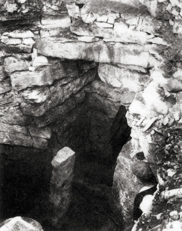
The entrance to the collapsed Cairn H.
Click to view in high resolution.
Carrowmore (Co. Sligo); originally contained up to 45 tombs.
Carrowkeel (Co. Sligo); 15 tombs.15
Loughcrew (Co. Meath); more than 30 tombs.
Brú no Bóinne (Co. Meath); 35-40 tombs.
The tombs of Carrowmore, with their chambers simply constructed of large boulders, constitute the earliest and least architecturally sophisticated of the passage tombs. The people responsible for building the Carrowmore cemetery might have emigrated east, using the river Uinshin, which leads from nearby Ballisodare Bay all the way to Lough Arrow, just below the Carrowkeel promontories. The monuments built there, with short passages leading into the (mostly) undecorated tombs, would represent a slight elaboration of the original passage tomb form. The Loughcrew cairns and those on the Boyne would be the culmination of the genre, with long passages featuring large slabs with extensive rock-art decoration leading to a large cruciform chamber.16
We do not know what ritual function, in addition to the sepulchral, the passage tombs served for these cultures. A reverence for the sun is suggested by the alignment of many of the passages to the rising or setting of the sun on yearly solstice or equinox events. The Carrowkeel tombs also seem to be oriented toward the cairns at Carrowmore and Knocknarea. Some tombs’ deposits included what may have been fertility symbols, such as rounded balls of stone, or even a decorated stone phallus. The facade of Carrowkeel’s Cairn K may have once been lined with quartz in a manner similar to that seen today at Newgrange, providing a brilliant sheen to the monument in certain lighting conditions.17
The Monuments
We will describe here the five passage tombs that may be visited in the media on this page: Cairns E, F, G, H, and K. The hut sites are also explored. Additional information on these as well as all the other cairns of the Carrowkeel Complex may be found at Martin Byrne’s web pages on Carrowkeel. The descriptions below are for the most part taken from the 1912 report of the archaeological excavations from the preceding year.
“We have no means of knowing when this settlement came to an end, or what was its ultimate fate. But Irish archaeologists are to be congratulated on the fact that, save for some structural failures, and the minor depredations of boys, the chief monuments of the series have kept their main secrets intact during the centuries that have elapsed since the last interment was made within them.”
R.A.S. Macalister, 191218
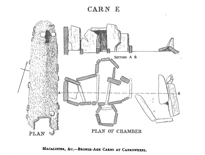
Cairn E
Located on a their own ridge of the Bricklieves, known as Carn Mór, Cairns E and F are 366 m (1200 ft) southwest of the most visited cairns of the eastern ridge (G, H, K and L). While these four have their own parking area and a steady stream of visitors, Cairn E is more difficult to access, with a barely discernable trail leading up to it from the north end of its ridge. This difficulty of access however, means that visitors determined to make the trek up here will more likely than not be rewarded with silence and solitude.
The cairn stands apart from the other Carrowkeel cairns in its shape as well, in a 2.5 m (8 ft)-tall elongated mound 37 m (120 ft) long but only 11 m (35 ft) wide. It has features resembling a court cairn at its south end, which the excavators said was “an arrangement of large slabs on end, the disposition of which can scarcely be described in words.”19 At its north end they found the cruciform chamber of a passage tomb, apparently opened long before Macalister’s time. This is where the viewpoint in the virtual-reality tour is centered. Note: Macalister’s plan of this, and the other three tombs featured in our VR tour, are reproduced in the gallery at the bottom of this page.
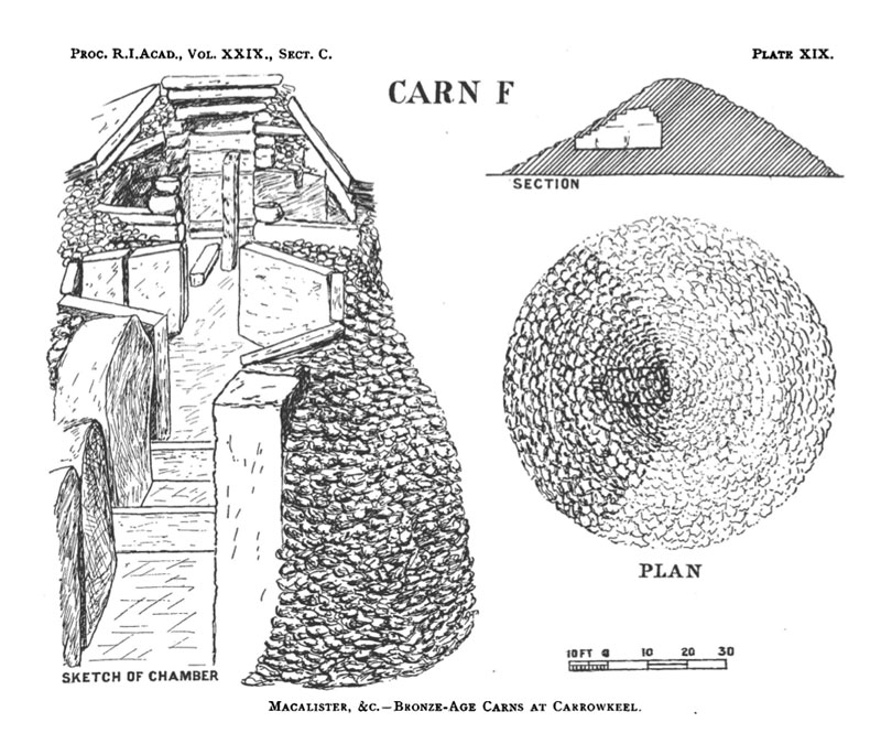
Cairn F
“An anthropomorphic god and goddess were worshipped in a religion which emphasized to the point of fetishism the principle of fertility in the house of the dead.”
Michael Herity, Irish Passage Graves, 197520
Located some 200 m (656 ft) south of Cairn E, Cairn F is the largest of the Carrowkeel tombs, and was likely the most significant, or the “focal” monument of the complex due to its size and the fact that it is the only of the Carrowkeel group visible from the south as well as the north.21
Macalister’s photograph of Cairn F’s inner chamber shows the standing stone.
Also making this monument extraordinary was the fact that its inner recess featured a non-structural standing stone, placed in a prominent position in the burial chamber. As indicated by Michael Herity (above), the placement of the standing stone inside a passage tomb may have been intended as a fertility symbol. Pendants, likely phallic in design, were also found in the Carrowkeel excavations (see image, below left). This cairn is one of the very few passage tombs in Ireland to contain a standing stone inside. On certain mornings of the Celtic calendar the rising sun illuminates another such stone, standing beside the most significant chamber of Loughcrew’s Cairn L. A standing stone was also said to once stand inside, or on the summit of, the great mound of Newgrange.
The Cairn F standing stone, already broken in two when discovered in 1911, was originally 1.5 m (5 ft) tall. Macalister estimated that the roof of the chamber once extended 3.4 m (11 ft) above the top of the stone. Ashes from a human cremation were discovered on the fallen section. Macalister noted: “It is possible that the resting-place [for the ashes] was chosen on account of some special sanctity attaching to the stone; for after much discussion we can find no satisfactory alternative to regarding it as a religious emblem.”22
After their breakneck-speed excavation of Cairn F in 1911, Macalister and his crew left the tomb collapsed and filled in with cairn debris. Since it was in their way and they had not the time to remove it, they broke up the four-ton capstone; its remains now lie inside the chamber. The cairn, with a diameter of 26.5 m (87 ft), was originally about 7.6 m (25 ft) high. It had a 3.6 m- (12 ft-) long passage separated by a sill-stone from the central area with its five chambers.
“The question presents itself whether we may not have here something more than a mere burial-place. May we not have some sort of temple? The grandiose scale of the architecture, the large entrance doorway, the peculiar ground-plan, and, above all, the standing stone, all mark this cam out conspicuously from the rest.” 23
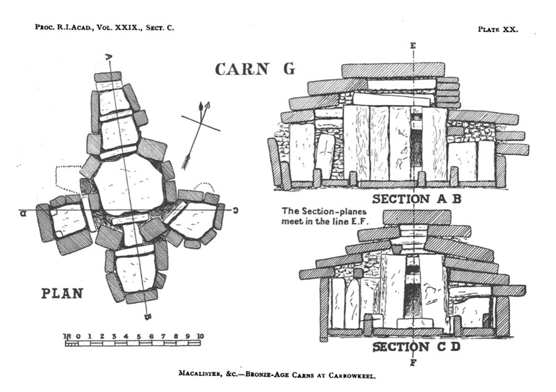
Cairn G
Visitors to the Carrowkeel ridge with the convenient parking area will encounter Cairn G soon after they begin the trek up the footpath of soft peat. With a diameter of 21 m (69 ft) this cairn is the best preserved of the entire complex. There is some suggestion of a kerb, but its stones, if present, keep their secrets from underneath the peat. An unusual door slab with a long vertical slit has been moved aside to open the entrance. This slit is most easily noted from the viewpoint inside the tomb, featured in the VR environment. While the visitor must crawl to enter the tomb, once inside there is room enough in the large chamber for several people to stand. When entered in 1911 the floor of the chamber and its three recesses were paved with limestone flags, now underneath a layer of loose cairn stones. The walls are made of eight huge orthostats, trimmed and fitted into place with astonishing precision and design sense. According to Macalister:
“It is impossible to secure a photograph that does justice to the building, which, though it may seem an exaggeration to say so, is beyond all praise as a veritable work of art. The builders aimed not merely at a building which should remain standing: they evidently took a pride in erecting a neat and symmetrical chamber.” 24
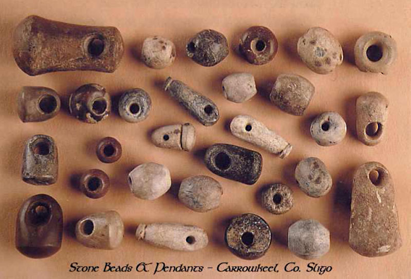
Semi-precious stones, such as jasper and serpentine, were among the materials found in the beads and pendants discovered at Carrowkeel. (NMI).
Perhaps the most engaging feature of Cairn G may be a roof-box, a feature not unlike that at Newgrange, with a possible astronomical orientation focusing the light of the summer solstice sunset through the roof-box and into the chamber for six or seven weeks on either side of the solstice. Local guide Martin Byrne has proposed an additional alignment to the setting of the moon at the winter solstice. Some scholars have suggested that astronomical orientations were used as a prehistoric display of knowledge and power “used by elites to demonstrate and maintain their authority over the masses.”25 Others are concerned with the questions of authenticity around the validity of these orientations.26 But the growing numbers of visitors annually making the visit up to the Cairn G on the evening of the June solstice may attest to the draw of the phenomenon. Archaeologist Robert Hensey, though cautious about the “roof box” interpretation for Cairn G, described his own solstice experience:
“Once evening falls, a pale bright beam of sunlight starts to penetrate the left-hand side of the passage. As the light advances further down the passage, the color slowly transforms into a much deeper golden hue. These changing shades are exquisitely canvassed against the smooth grey limestone orthostats…Finally, as it alights on the orthostat to the left of the end chamber it progresses through several remarkable shades of rose-pink until it finally fades, and soon the experience is over; the light inside the tomb diminishes quickly in the grey afterglow of the sunset.” 27
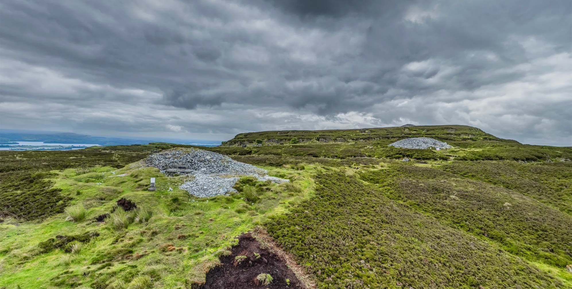
Cairn H
Although the entrance to Cairn H may look (see photo above left) as enticing to the visitor as that of its neighbors G and K, an attempt to gain entry here will result in disappointment. This monument, initially some 30 m (98 ft) in diameter, was sadly vandalized by those entrusted with its excavation in 1911. Macalister’s team tunneled in through the roof when they found the passage blocked by a fallen stone. Excavating tons of stones, with no plan or intention of restoration, they left the monument in the collapsed state the visitor will find it in today. A double row of curbstones surrounds the cairn.
“When the loose stones in the passage were cleared out, indications of a rough floor of flat stones were seen, below which were obtained a skull and a large number of human bones, many of them unburned…” 28
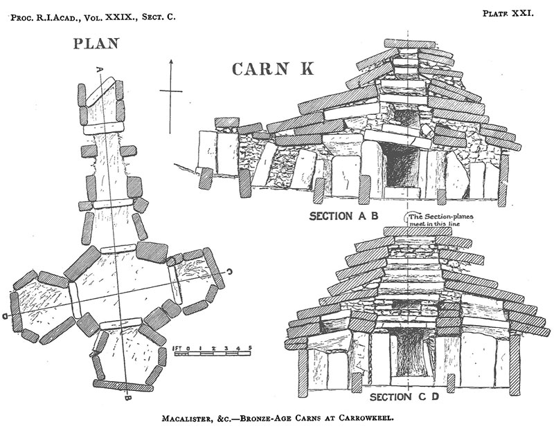
Cairn K
This cairn is another that may be entered in the VR tour (top left). In the physical environment, as opposed to the virtual version, it is a tight squeeze through the 7 m (23 ft) passage into the cruciform chamber. Once inside, the visitor may choose to stand; the corbelled ceiling is a full 370 cm (12′ 2″) in height.29 Outside, the top of this 22 m (71 ft) mound is the highest point on Carrowkeel, at 324 m (1,062 ft). The 360° view from the atop the mound may be explored in the VR tour, but due to instability noted recently visitors are urged not to scale any of the intact Carrowkeel cairns.
Until removed by decades of souvenir hunters, pieces of white quartz were to be found around the entrance at the north face of the monument. This sparkling stone may have once been attached to the face of the mound to make it more visible from a distance, and perhaps might explain the origin of the name Bricklieve (Speckled Mountain). The orientation of the passage seems to point toward the massive cairn of Miosgán Meadhbha on the summit of Knocknarea some 25 km (15.5 miles) away, a monument located at the same height as Cairn K. The sightlines from Knocknarea to a number of the tombs of the Carrowkeel Complex may be visualized in the telephoto VR environment, bottom left.
The Hut Sites
There is no one living now on the flat and rocky plateau of Mullaghfarna to the east of and below the main Carrowkeel cairns. The spot had a brief footnote in historical times, when Red Hugh O’Donnell and his army may have camped on this high ground before their victory at the Battle of Curlew Pass in 1599. But thousands of years earlier it housed a large community in its more than 150 hut enclosures. Their circular stone foundations, with diameters ranging from 6 m to 20 m (19 ft to 65 ft), still mark the spots where the tent-like huts stood. The Doonaveeragh outcrop above the hut sites is where Cairn O (noted in the VR tour) and Cairn P are located.
Macalister first noted the Mullaghfarna Neolithic village, the largest one known in Ireland, in 1911, although he identified only 47 enclosures. With only the bare rock surface, similar to that of the Burren in Co. Clare, it was believed that an archaeological excavation here would not be productive. But a trial excavation in 2003, and ongoing fieldwork and remote imaging by Stefan Bergh, has discovered, by probing into the grykes (fissures) of the limestone, evidence of occupation from both the Neolithic and the Bronze Age.30
Not many visitors to the Carrowkeel cairns extend their excursions to include the Mullaghfarna hut sites, located well beyond the dire “road unsuitable for vehicles” sign at the parking area for the cairns.31 But the prehistoric village is likely connected to the cairns. Some have postulated that the huts housed the army of workers who built the passage tombs, or perhaps the legions of their descendants who continued to assemble at the cairns for their ritual observances.
The Finds
“By a careful process of sorting of the fragments and counting the bones that were best preserved, it was possible to arrive at an estimate of the minimum number of individuals represented. In this manner I ascertained that there were bones representing thirty-one skeletons. These, however, constituted only a very small portion, and included only the least perfectly burnt. I think it is a safe conjecture to estimate the number as at least double that limit…It is evident that many of the people buried in the carns were under twenty-five years of age. None showed signs of senility.”
Professor Alexander Macalister, 191232
While they did not recover any of the bronze or gold ornaments they had hoped to find, R.A.S. Macalister’s team found within the different cairns numerous bone fragments, both burned and unburned. Unfortunately for Irish archaeology these were shipped off for anatomical analysis in 1911 to Professor Macalister’s laboratory in Cambridge where their storage and record keeping left much to be desired.
Modern archaeologists in Ireland were in 2004 able to perform carbon dating using bits of human bone found in the Carrowkeel cairns by visitors during the 1960s and 1970s, evidently the odd pieces missed by Macalister’s rapid inventory of 1911. A collection of some 200 fragments of cremated bone were found on a ledge in the back recess of Cairn G, placed there by those who found them on the floor of the chamber. Calibrated radiocarbon dating of these fragments determined them to be from 3517 BCE to 2762 BCE.33
Other bones indicated the domestic or sacrificial animals used by the populace, such as ox and bear. The finds included items likely of a ritual nature: bone pendants and tools of bone or stone. Pins of bone with expanding heads may have been used to fasten the cloth bundles in which the cremation ashes were collected for deposit in the tombs. As in other burials from that period in Ireland, the remains were often accompanied with water-rolled white stones. A dozen of these were found outside the doorway of Cairn K, presumably “believed to have some magical significance.”34
Carrowkeel has given its name to the characteristic Late Neolithic form of pottery uncovered in the cairns: Carrowkeel Ware. This is typified by a thick, coarse, and heavily gritted material used to form mostly open bowls with rounded bottoms. The outsides and rims of the bowls are often extensively decorated, using a “stab and drag” technique.35 The excavators found only small fragments in the cairns, making it difficult to reconstruct or to accurately visualize an intact vessel. Efforts at such reconstructions were made, however, as may be noted by the sketches in the gallery at the bottom of this page.
“Many attempts at restoration have been made; but the fragments were so small and so much was missing that, except in one case, nothing of importance has been effected.” 36
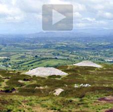
Click to enter a VR tour linking cairns on four Co. Sligo summits: Keshcorran, Knocknarea, and Carrowkeel Cairns F and K, where the tour opens. View full screen to use the interactive map.
Conclusions
Archaeologists today are taking a wider view of how the passage tombs and other megalithic monuments of the area ought to be considered. Stefan Bergh coined the term “Carrowkeel-Keshcorran Complex,” highlighting the interconnectivity, both in geographic proximity and in possible prehistoric ritual practice, of the cairns at Carrowkeel and those to the west at Keshcorran. Bergh extended Macalister’s naming convention to the Keshcorran tombs: Q, R, S, T, U, and V (see annotated satellite view, above right).37 Furthermore, as Bergh phrased it, these monuments seem to show an “ideological communication” with the tombs of Knocknarea and Carrowmore to the west.38 It is because of the potential of this interconnectivity that we have created the virtual-reality feature (left) that ties together some of these monuments using telephoto views from the tops of the cairns. All told, there are 27 “related passage tomb tradition monuments” in the Carrowkeel-Keshcorran Complex, a total that includes three monuments located nearby but not in the Bricklieve Mountains.39
Of course, one can only wonder about the ritual practices and the spiritual motivations of those who buried their dead within the 27 tombs of the complex. Macalister speculated that their intentions were:
“…either that the deceased tribesmen should overlook as wide an area of the clan territory as possible, or that the monuments themselves should be a centre upon which eyes could be turned from the remotest limits of the lands of the tribe.” 40
From the numerous and often heartfelt and poetic accounts modern visitors have provided in guidebooks, travel diaries, and blog posts it is clear that the Carrowkeel cairns have remained for nearly six millennia “a centre upon which eyes could be turned.” The remoteness, difficulty of access, and the unique experience of crawling on one’s belly into an artificial “cave of the dead” built in the Stone Age continues to have a profound effect on thousands of visitors each year. Added to the experience may be the panoramic sights of a fine summer day providing a postcard view of Lough Arrow and extending to other hilltop monuments as far away as Knocknarea. Alternatively, the dismal atmospherics of a winter’s fog, or a drenching rain, may chase a visitor into a passage tomb for its dry and welcome shelter.41 As archaeologist Sam Moore has noted:
“The mountains have rifts, cliffs, caves, glacial erratics, the resources of forest and water, and the heights of the hill provide a proximity to the sky. All of these elements may have attracted forms of pre-monumental religious attitudes towards the mountains. In my opinion the natural features and the physical landscape of the Bricklieve Mountains formed a cultural framework of movement, meaning and memory to a pre-monumental society and this in turn may have greatly influenced the need to ‘alter the earth’ and construct the megalithic monuments…”42
The power of a place such as Carrowkeel on the modern imagination has created its own folklore and New Age spiritual practices. The light-show put on yearly by the summer solstice sunlight streaming through the roof-box of Cairn G, as well as more arcane archaeoastronomic and “earth energy” observations popularized by Michael Poynder’s Pi in the Sky (1992),43 have resulted in some offerings left in the tombs that might have astonished R.A.S. Macalister were he to have encountered them in 1911. Sam Moore, while investigating Cairn V (Treanmacmurtagh) discovered that a previous visitor had left candles, crystals, and a replica of a goddess figure.44 Perhaps a thousand years from now these artifacts will be the subject of much academic debate regarding the spiritual practices of the 21st-century Irish.
The power of a place such as Carrowkeel on the modern imagination has created its own folklore and New Age spiritual practices. The light-show put on yearly by the summer solstice sunlight streaming through the roof-box of Cairn G, as well as more arcane archaeoastronomic and “earth energy” observations popularized by Michael Poynder’s Pi in the Sky (1992),43 have resulted in some offerings left in the tombs that might have astonished R.A.S. Macalister were he to have encountered them in 1911. Sam Moore, while investigating Cairn V (Treanmacmurtagh) discovered that a previous visitor had left candles, crystals, and a replica of a goddess figure.44 Perhaps a thousand years from now these artifacts will be the subject of much academic debate regarding the spiritual practices of the 21st-century Irish.
CARROWKEEL
If I can’t be buried
in one of these passage graves,
nameless, without epitaph,
a stone bowl for these bones
instead of some municipal
rectangle, at least let me return
as the raven who watches over
these hills.
Then I could fly
cronking around like God’s
only machinery, and roll up
and peel off down Sligo
over green ringforts
untouchable to the men
who plow around them.These cairns look like
the rubble of roadwork schemes
infinitely postponed. We crawl
under an east-facing lintel
into the earth, and rise in church-cool,
stone-dusted air to admire
in flashlight the corbelled ceiling,
the capstone worked uphill with others
from miles below the mountain.It would make death
worthwhile if I could hire
the secrets of four old men red-faced
as the sun, their suits worn
from fieldwork, mannerly talkers
who weigh the arts of levering
stones with fire-cured poles.To have an east-facing door
someone from the future
might crawl into, some winter solstice
in four or five millennia, to wait
long enough for sunrise to strike through.
Brendan Galvin, 1989 45

Click here to see all the notes from this page.
Carrowkeel Megalithic Cemetery, Co. Sligo
Nearest Town: Castlebaldwin
Townlands: Carrowkeel, Carricknahorna West, and Mullaghfarna
Latitude: 54° 3′ 21.55″ N
Longitude: 8° 22′ 41.18″ W
External Link:
The Sacred Island: Carrrowkeel